
This feature describes Oak Ridge National Laboratory research presented at the 98th annual meeting of the Ecological Society of America. The theme of the meeting, held Aug. 4-9 in Minnesota, is “Sustainable Pathways: Learning From the Past and Shaping the Future.”
Trees have existed on Earth for nearly 400 million years, and today about 100,000 species populate the planet. Increasingly, trees are placed at risk by climate change, which spurs heat waves, droughts, fires and infestations. Plants cannot easily adapt to quickly changing conditions or migrate as habitable lands shrink owing to expansion of cities and croplands. Projecting the future of forests requires knowing what tree species exist where, and under what environmental conditions they can survive and even thrive.
“We are working to understand conditions and quantify the suitability of known habitats for particular tree species and identify regions that have similar conditions in the present as well as in the future under various climate change scenarios,” said Jitendra Kumar, a researcher with Oak Ridge National Laboratory’s Climate Change Science Institute. Along with collaborators, Kumar presented a paper on mapping tree species Aug. 6 in Minnesota at the Ecological Society of America’s annual meeting. “This has implications for forest resource management today and a greater implication for the future, given variations in environmental conditions due to climate change.”
Kumar and Forrest Hoffman, both experts in data analytics algorithms at CCSI, have teamed with Kevin Potter of North Carolina State University and William Hargrove of the U.S. Department of Agriculture Forest Service on a Forest Service–sponsored project to map trees in the contiguous United States. The results will aid in management of the nation’s forest resources, particularly tree species that are rare or economically important.
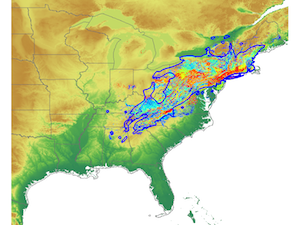
Kumar and his colleagues created a statistical delineation of the world into 30,000 uniquely defined ecoregions based on fairly high-resolution climatic and soil-related variables. Although the initial analysis of the large, complex Earth science data set was performed on small in-house computers, the project will require use of some of ORNL’s supercomputing resources for planned future analysis. “ORNL plays a key role in developing the data analytics approaches and computational tools crucial for this project,” Kumar said. “The Multivariate Spatio-Temporal Clustering methodology employed in this work was developed at ORNL, and the lab is one of the few places in the country that possesses the resources for this data- and computing-intensive work.”
Through the mapping process, researchers are identifying the range of conditions in which various tree species can survive and how those environmental characteristics influence tree productivity. “We can paint a future scenario for these trees and plan ahead for forest resources management in a changing climate,” Kumar said. “Trees in areas of changing conditions are potentially at risk. Based on our ‘presence and absence’ mapping of about 200 tree species during the most recent phase of our efforts, most are expected to see reduction in their suitable habitat under warming climates, and a handful will gain more suitable habitat area.”
Trees have the ability to adapt and migrate, but the processes require adequate time. Researchers must understand the connectivity of the landscape to determine if it supports species migration or if human intervention will be required to place trees in suitable habitats. “We know there’s not enough time for the trees to actually migrate on their own through natural process, and they may need human-assisted migration to places where we think they will be able to grow,” he said.
The mapping process currently includes tree species in the contiguous United States in grid cells about four square kilometers (2.48 square miles) in area. Kumar said ground data comes from the Forest Service’s Forest Inventory Analysis, an archive that provides long-term observations for the health and productivity of forests through a large number of research plots across the nation. “Available data are very limited since FIA plots are expensive to monitor,” Kumar said.
To use the data collected on the ground by the Forest Service as well as data collected from remote sensing satellites managed by the National Aeronautics and Space Administration, researchers employ a clustering technique to delineate ecoregions using a large set of variables. Next, they constrain the species range projections across these ecoregions using observations from FIA plots and locations monitored by the Global Biodiversity Information Facility, an international organization that collects and shares worldwide data on biodiversity.
The project focuses on a key point, according to Kumar: “We have the data for tree health and productivity at sparse observation locations across the country, and we also know the environmental conditions at those places. What is the relationship between those two kinds of information, and how can we upscale the information to the entire country in an objective and quantitative way?”
Upscaling refers to an analysis method for projecting point measurements (in this case, observations from FIA and GBIF) to develop continuous maps of tree species productivity.
To determine the relationship between tree health and environmental conditions, researchers are developing techniques to compute the suitability of different conditions in a quantitative manner and to develop statistical models of habitat suitability that can be applied to areas not directly studied and observed. They have completed mapping for the current climate in the contiguous United States and are now in the early stages of mapping species extent and estimating productivity under future climate scenarios in the same region.
For future climate scenario projections, researchers are using results from the Met Office Hadley Centre, a climate change research center in Great Britain, and the National Center for Atmospheric Research in Boulder, Colo. The data are from two global, parallel climate simulations performed for the third phase of the Climate Model Intercomparison Project, which was performed for the Intergovernmental Panel on Climate Change Fourth Assessment Report.
The project is also being expanded to other countries: ORNL-led researchers have already created presence/absence maps for a variety of species around the globe. “We are now developing more quantitative methods and using FIA and GBIF observations to predict productivity for woody tree species under present and projected future environmental conditions,” Kumar said. “We expect to complete the first version of these maps employing our new analytics method by the end of the year.”
The U.S. Department of Agriculture Forest Service provided funding for this project.
- Wendy Hames, 865.241.2481, August 08, 2013